How to Plan a Road Trip With Multiple Stops
How to plan a road trip or a trip with multiple stops in 8 steps: route, stops, daily driving, stays, booking order, border papers, offline maps.
 By Elad · Nov 21, 2026 · 7 min read
To plan a road trip, fix your start, end and must-see stops first, then cap how long you'll drive each day, split the route into overnight bases, book stays in order of scarcity, and sort documents and offline maps before you leave. The same steps work for any trip with multiple stops, by car, train or plane.
Keep the plan itself in NomadPoint (we make it): your stays and activities sit day by day on a map, with the time between stops, alongside any flights and the entry rules for each country. For turn-by-turn driving, use a routing app such as Google Maps; NomadPoint doesn't do navigation.
The short answer:
- Pick start, end and must-see stops.
- Sketch the route in a routing app.
- Set a daily driving limit and split the route into days.
- Choose overnight bases.
- Book in order: car, scarce stays, then the rest.
- Check documents for every border.
- Download offline maps.
- Put the day-by-day plan in one place.
Facts and app limits below come from official pages checked on 21 November 2026.
Step 1: Pick your start, end and must-see stops
Write down where you start, where you finish, and the three to six places you'd be disappointed to miss. Everything else is optional. Decide early whether you're looping back or ending somewhere else, because it changes the car hire and the route.
Step 2: Sketch the route in a routing app
Put the stops into a routing app to see the real distances and driving times.
- Google Maps lets you add up to 9 stops, including the final destination, for driving routes.
- Roadtrippers is built for road trips. Its plans page lists 3 stops per trip on the free plan, 20 on Basic ($35.99 a year), 50 on Pro ($49.99) and 150 on Premium ($59.99).
Use the routing app for the road, not for the whole trip. It knows distances and traffic. It doesn't hold your hotel bookings, activity times or entry rules.
Step 3: Cap your daily driving time
Decide the most you'll drive in a day and stick to it. The UK Highway Code (rule 91) recommends "a minimum break of at least 15 minutes after every two hours of driving", so add those breaks to every leg. Then split the route into days that fit your limit, and leave a lighter day every few days for weather, detours or simply staying put.
Step 4: Choose overnight bases
Group nearby stops around one base and stay two or more nights where you can. Fewer check-ins means more time seeing things and less time packing the car. For a deeper look at splitting a trip into bases, read the multi-city trip planner guide.
Step 5: Book in the right order
- The car, if you're hiring one, and check the one-way and cross-border rules.
- Stays in small or popular places that will sell out first.
- Timed activities such as tours or tickets with set slots.
- City stays and flights that have more choice.
Prefer free cancellation where you can until the route is final.
Step 6: Check documents for every border
If you cross a border, check the entry rules for every country on the route for your passport. Here's how to check entry requirements for any country. For Europe, also watch your 90 days in any 180 with our Schengen calculator.
For the car, GOV.UK's driving abroad guide lists what UK drivers may need:
- an international driving permit in some countries, £5.50 from certain PayPoint shops, possibly one per country,
- your log book (V5C) and insurance certificate for your own car, or a VE103 for a hired or leased UK vehicle,
- a UK sticker if the country requires one,
- the right insurance, and a green card if that country needs it.
Rules on speed limits and drink-driving also change at every border, so check each country.
Step 7: Download offline maps
Signal drops on mountain roads and in rural areas. In Google Maps you can download an offline map of an area, and it will guide you "as long as the entire route is within the offline map". You won't get traffic or alternative routes offline, and offline maps expire, so update them before you go.
Step 8: Put the day-by-day plan in one place
This is where most multi-stop trips fall apart: the hotel is in one email, the tour in another, the ferry in a PDF. NomadPoint, the app we make, puts flights, stays and activities in one journey, day by day, and shows each day on a map with the stops in order and the travel time between them.
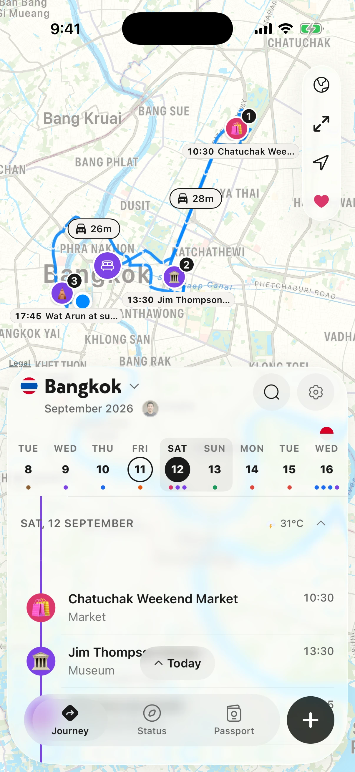
One day of the trip: the stops on the map, time between them, and the timeline below.
Each day of a multi-stop trip gets the same view, so you can see whether a day is overloaded before you're living it.
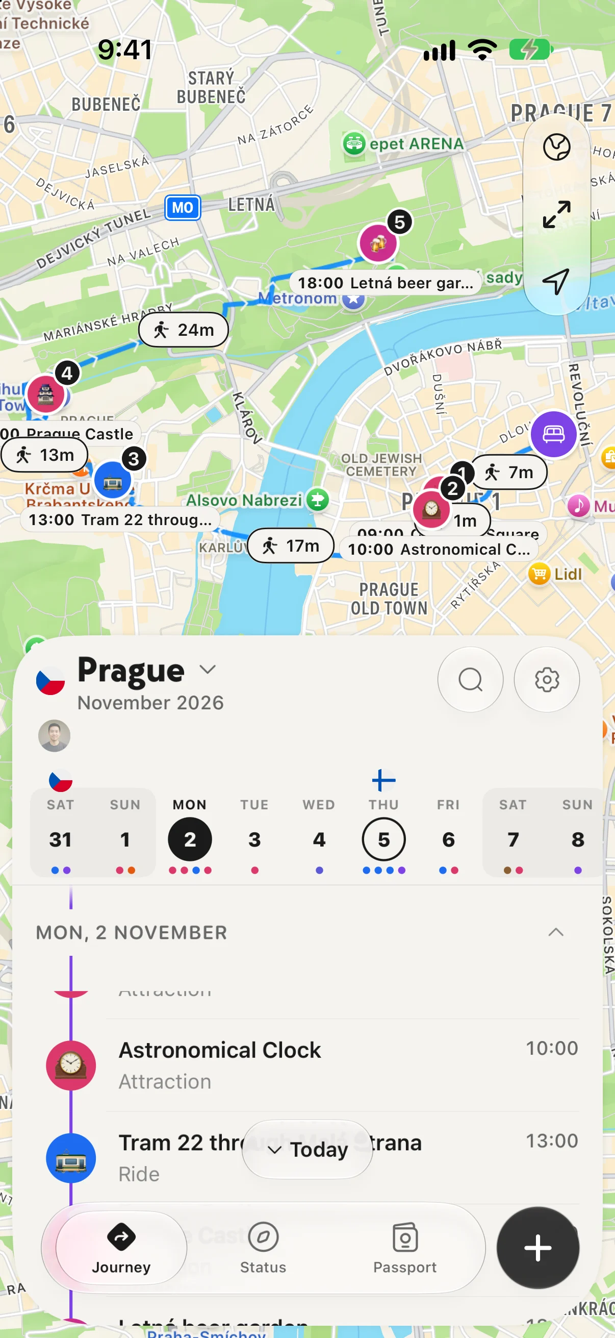
A city day on foot: five stops, the time between them, in order.
The whole itinerary works offline, which matters on the road. Forward a booking confirmation and it lands in the journey (the first one is free). If you cross borders, each country gets an entry card with the rules for your passport.
| NomadPoint | Google Maps | Roadtrippers | |
|---|---|---|---|
| Built for | The trip plan: stays, activities and flights day by day on a map | Directions | Road trip routes and stops along the way |
| Turn-by-turn driving | No | Yes | Navigation listed on its plans |
| Stops | Unlimited journeys, free | Up to 9 per route | 3 per trip free, up to 150 paid |
| Entry rules per country | Yes, 1 free, all with Pro | No | No |
| Offline | The whole itinerary | Offline maps | Offline maps listed on its plans |
So use both: NomadPoint for the plan, a routing app for the drive. The plan is free with unlimited journeys. NomadPoint Pro is $39.99 a year with a 7-day free trial and adds the best order for a day's stops, weather on the itinerary, entry rules for every country and live flight alerts if the trip includes flights (see pricing). It runs on iPhone, iPad, Mac and Apple Watch only. On Android, Google Maps plus a simple document is a reasonable fallback; our trip planner app vs spreadsheet piece compares the two.
FAQ
How do I plan a road trip?
Pick your start, end and must-see stops, map them in a routing app, set a daily driving limit, choose overnight bases, book the car and scarce stays first, check documents, and download offline maps.
How do I plan a trip with multiple stops?
Group stops into bases where you stay two or more nights, order them along one direction, and keep every booking and activity in one day-by-day plan so you can see each day's load.
How many hours should I drive per day on a road trip?
Set your own limit and plan breaks. The UK Highway Code recommends at least a 15-minute break after every two hours of driving.
What is the best app to plan a road trip?
For the plan with stays and activities day by day on a map, NomadPoint on iPhone, iPad and Mac. For the driving itself, a routing app such as Google Maps or Roadtrippers.
Plan the days, then drive. NomadPoint keeps every stay, stop and border of your road trip in one journey.
Elad · Founder of NomadPoint
I build NomadPoint and write these guides. Spot something wrong or out of date? Write to me at support@nomadpoint.app.